Friday, March 9, 2012

Mount Defiance winter night hike

(sunrise from Mount Defiance summit)

This week, I planned on climbing the south side of Mount Hood again, and while the weather looked great, the avalanche reports were not, so I was left looking for an alternative.  I had heard there was a recent surge in solar activity, and that the aurora borealis might be visible from Oregon, so my plans remained to get somewhere high up and away from city lights at night.  My go-to training hike for when mountain conditions keep me off Hood has become Mt. Defiance.  The vertical gain is comparable to the Mt. Hood south side approach, and the lower elevation makes it more accessible when conditions aren't ideal.

(Mount Hood in the morning)

 Even though I had slept poorly the night before and put in a full day at work complaining of feeling a little out-of-it and worn out, I was motivated by the opportunity to see the aurora borealis, so I rushed home, grabbed gear and supplies, and was on the road by 8:00 pm.  Shortly after 9:00 pm, I was at the trailhead and making my way into the forest.  Mount Defiance is often considered the hardest day-hike in the region during the good season, and unhikable until late spring.  This is partially due to the snow, but also because the trail is unmaintained in the winter.  Not more than a few hundred yards into the approach, I encountered my first blow-down, and would spend the next 4 hours scrambling off trail with my hands on the ground because of hundreds of downed trees, sections of trail wiped away by mudslides, and other sections that were too hard to detect in low light under a blanket of downed limbs.  Without any discernible trail, I navigated by gps and compass; deciding to point in the general direction of the summit, and hoping to intersect the trail at some future point.  The wall of the gorge that I was climbing was very steep, and is usually ascended by using a long set of steep switchbacks.  Without the switch backs, the angle is too extreme to walk up, so I climbed with my hands on the ground, using exposed roots and branches from downed trees to pull myself up.  I didn't see any poison oak, but a thought back to a nasty case from a scramble in this area from the previous summer had me a little concerned to be grabbing at whatever foliage I could to progress up slope. This continued for 2000 vertical feet of gain and brought me to 1:30 am, when I was finally reunited with the trail to Mount Defiance.

(my tracks and Mount Adams)
 
The relative ease of navigating on the terrain above 2000' freed my mind to think about other things, and my imagination began to turn the shadows cast from my headlamp into bears or cougars - thoughts planted by seeing plenty of tracks from both on previous excursions in the area.  These invading thoughts caused me some alarm when I clearly heard something large moving in the forest below me.  When I turned to look in the direction of the sound, my headlamp faded between the trees into complete darkness briefly, and then the reflection of two large eyes appeared as an animal faced my beam of light.  Then two more sets of eyes appeared, and I was certain they were just deer, which was confirmed as they began to move, and the way the reflections bobbed in the darkness demonstrated their gait.

(Mount Adams and the Columbia River)

In a short distance, the branch-littered ground gave way to snow, and at about 2500' it was thick but well consolidated.  I wasn't post-holing, but the grade was causing me to lose traction, so I donned my snowshoes, which have aggressive crampons and heel lifts which significantly reduced the strain on my calves.  The trail was easier to follow in these conditions than I had expected, and I continued on like this for another 2000' of gain.  It was in this section that I quietly and briefly heard the sound of two people's voices in the distance.  It sounded like there was a man and a woman, and they were talking, but it didn't make sense on this trail in the winter, especially at this hour.  I hiked on.

(Mount Adams)

At around 4500' of gain, the trees opened up to large open snowfield. It was as this time that I was first Mount Adams and Mount Saint Helens in the distance.  Illuminated only by the light of the moon, they were crisp and white on the horizon.  I stared north for some time, hoping to see the aurora, but nothing appeared, so I pushed on across the crusty snow.

(Mount Saint Helens and Mount Rainier)

At 4:30 am, I reached the summit.  For the uninitiated, all three north approaches to Mount Defiance are challenging climbs from the Columbia river through beautiful and natural terrain, but the south side of the mountain has an access road leading to the summit, which is marred by an ugly radio tower facility.  In the predawn darkness, I explored the facility.  The road to the summit hdn't been plowed all winter nd ws under many feet of snow, and I noted that my tracks were the only ones present here, indicating the summit hadn't been visited in some time.  The snow depth was as high as the chain-link fences that surrounded the radio equipment. 

(Making tracks)

At this point, the exhaustion carrying over from the night before, compounded by nearly 24 hours without sleep and 5000' feet of demanding vertical climbing set in fully, and my body went on autopilot, thinking only of sleep.  The summit was exposed, well below freezing, and very windy, so I retreated back down into the protection of the trees to find a place to lie down.  I found a large tree which had blocked enough windswept snow to create a hole as wide as the trunk and 3' in depth behind it.  I removed one of my snowshoes and used it to dig the hole to a length long enough to accommodate my body.  I lined the trench with a mylar emergency blanket I had carried, unrolled my sleeping bag onto it, removed my boots, and climbed in.  I ate a peanut butter sandwich from my pack, set my alarm for sunrise, which I guessed was only 45 minutes later, and settled in to sleep.  There in the darkness, from my hole in the snow, I heard the voices again.  They were similar to the ones I had heard before.  Faint, unfamiliar, but... there.  It couldn't be though; it just couldn't.  Who would be up here in these conditions at this time?  I had covered a lot of ground and saw no tracks.  I had to be alone.  My mind thought of outlandish explanations to rationalize away what I was experiencing: "maybe it's the radio towers... am I somehow detecting a broadcast?"  Then I heard a new voice.  A familiar one.  A family member.  She wasn't talking to me, or anyone in particular, but I recognized her voice, and she said clearly and loudly "I'm sick of it!".

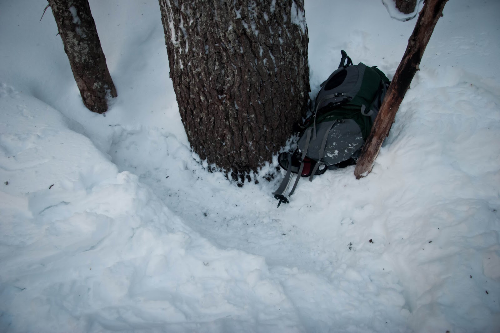
(this is where I slept)

I awoke 45 minutes later to my phone alarm.  I was quite warm, and when I poked my head out of my bag it was quite cold.  Sunrise hadn't yet come, so I hit snooze and retreated back into my bag.  15 minutes later the alarm sounded again, and I told myself "if I don't get these sunrise photos, then this was all for nothing."  I hastily packed up the mylar and my bag, put on my boots and snowshoes, and ran to the summit with my camera.  I was just in time, and took many photos before heading back down to retrieve my gear.

(Mount Saint Helens)

The trek back to the trailhead was much easier and less eventful than the nighttime ascent.  Before I knew it, I was taking my snowshoes off and entering the blow-down section.  I thought back to the night before, astonished I had decided to take on such a trip.  My memory of the night seemed less like a first-hand experience, and more like something I had watched someone else do.


When I reached my car, I drove back to Portland and collapsed in bed for the afternoon. When I awoke, I thought again about the voices.  A quick search on google turned up hypnagogia - the state between wakefulness and sleep, and hypnagogic hallucinations - auditory or visual hallucinations brought on by extreme exhaustion.  Articles on hypnagogic hallucinations describe the voices that I heard as the most common manifestation of the condition.  While still alarming, this explanation soothed my fears that I was finally losing it.

Monday, February 6, 2012

To the Bergschrund.


When I last went up the mountain to Illumination rock, I had set my next goal at the crater passed Devil's Kitchen, or maybe higher. This past week, the weather and avalanche reports were looking good for Mount Hood after weeks of more typical winter conditions, so I decided to take advantage of a day off, and see how much further up the mountain I could proceed.

I woke up in Portland at 3:30am, and was on the road shortly after 4:00. The plan was to get to the mountain early enough to get to the higher elevations while the snow was still stable. This required beginning the hike before sunrise with the aid of a headlamp. When I arrived at Timberline Lodge, I parked my car among a half dozen vehicles that were in the lot already, and made my way up the now-familiar climbers route to get above the ski area. The beginning of any south approach ascent begins with a trudge up past the Magic Mile and Palmer ski lift areas. From this elevation in the predawn darkness, I could easily see the lights of Portland to the west, as well as the whereabouts of the climbers ahead of me on the mountain from the glow of their headlamps. The sun began to light the skies to the east with gorgeous oranges and reds by the time I was half way up the Palmer lift. Around this time I could see two climbers making their way up the ridge towards crater rock, as well as some light coming from the crater itself and a skier beginning an early morning run from more than 10,000 feet. I took several photos of the sunrise and the light creeping up on Mt. Hood on the various peaks to the south, and then continued my trek to the top of the Palmer lift.


Beyond the softened tracks of the climbers route, the surface of the mountain was slick and icy, making it impossible to proceed without crampons and an ice axe. I stopped here to change my gear out and have a sandwich before continuing to higher elevations. From the top of the lift to all points further up the mountain, there are no set routes and the hard snow and ice on the way up to the crater rarely shows the tracks of previous climbers in the winter, so you're left to find your own way. I followed the crest of the ridge to the east of the snow field below crater rock on my ascent. This probably wasn't the best route. While direct, the icy rock and proximity to the cliffs to the east made this a more difficult and exposed route than I had intended to take. Still, the views were stunning, and with some effort, the ridge route brought me to just under the east side of crater rock, ready to climb past Devil's Kitchen and into the crater itself. This last bit is particularly steep, and care must be taken to get good footing and maintain balance above the eastern cliffs.


As I entered the crater, the smells of sulfur intensified with the proximity to Devil's Kitchen and the various other fumaroles on the crater. I stayed close to the eastern edge of crater rock and made my way up to the hogsback. Another steep climb and I approached the spine and continued up the edge to the area of the bergschrund, which is most typically a crevasse where the glacier has pulled away from the rock of the mountain, but today was just a light indentation that had been filled with recent heavy snow fall.


At that time, I saw another climber up close for the first time on this trip. He was descending the mountain from the area of the old chute route, and we met at the bergschrund. He described his climb, and we discussed the conditions on the various routes to the summit. The pearly gates were described as a bit too icy to ascend without a second ice tool. The old chute and mazama chute routes were softer, but there was concern that the loaded chutes might be unstable after a morning of warm temperatures and intense light. At this point I decided to descend with the first climber, his partner, and another climber that also decided to turn back given the current conditions on the upper slopes.


Stopping just 500 feet from the summit was difficult, but I had already climbed higher than I intended to, and the mountain isn't going anywhere. I'll have to go again the next time the weather and avalanche reports are favorable, and wake up a bit earlier than 3:30 this time around.

Wednesday, December 7, 2011

Illumination Rock in December.

(returning from my trip to illumination rock)

After doing the Paradise Park trail in the snow last week and breaking out of the trees just under Mississippi Head to a great view of the top 5000 feet of Mt. Hood, I was inspired by the sight of its upper peaks, and decided to get the ice gear I needed to start working my trips a little further up the mountain. We had been having unusually clear weather for December in the Cascades, and beginning a week prior, the forecast looked especially good for Sunday. With a wary eye on the forecasts for changing conditions, I tentatively planned to make my first climb above the Palmer lift to Illumination rock. I discussed my plan with friends, and even arranged to go up with a buddy, but concerns about often dangerous and rapidly changing winter conditions on the mountain ultimately sidelined him until spring. Undeterred, I chose to go up the mountain alone the following day.

In the morning, I hit the road out of Portland about an hour before sunrise. After making a few stops for gas, snacks, and a sno-park permit for my car, I was in the timberline lodge parking lot by 8:00, suiting up for the trudge up Mt. Hood's south side. The first part of any climb from the south approach is just getting above the resort's upper ski areas. The lodge itself sits at 5960', but two lifts continue up the mountain from there, with the second topping out at 8540'. There were two ways to clear the ski area on this trip; paying to take a sno-cat ride up to the top of the Palmer glacier, or hiking up on foot in it's compressed tracks. Illumination saddle, at the base of the formation, tops out at about 9300', and although it is a nice glacial traverse to the west from the rest of the peaks (and the ski area), it would be impossible to justify knocking 2580' off a 3340' climb by hitching a ride up the mountain, so I chose to go by foot. It appeared that about half those on the mountain took the easy route, although most of them were just looking for access to the top of the ski area, and climbed no further.

(The view from the base of the climb. The top of the lift sits a couple miles and 2840' up slope. Illumination rock sits another 760 feet up slope and far enough to the west that it's not visible in this photo. The included peaks, from left to right, are Castle Crags, Crater Rock, and the Steel Cliffs.)

(This photo is taken from above the Silcox Hut, looking south west)

(Looking south at Mt. Jefferson with the Sisters making an appearance in the distance.)

At the top of the Palmer lift, I stopped to eat some lunch and take in the changing views to the south. The small plateau at the top of the lift serves as a staging area where climbers prepare to ascend above the groomed hiker's path, and skiers and snowboarders prepare for their descents. The area was also popular with the local ravens, which looked accustomed to being fed by hikers and climbers, and eager to accept handouts. While I ate, I watched a group of three men proceed from the lift area in the direction I was to head. They lost traction immediately and had to stop to affix their crampons before proceeding across the ice.

(mountain hoagie)


(friendly raven)

When I finished eating, I unstrapped my ice axe, and began my own traverse across the glacier toward illumination rock.
The first section was very slick indeed, and consisted of thick ice-coated rocks that were difficult to gain purchase on with my crampons or axe. Once over this rocky area however, the footing improved and I was able to move a bit faster. After a very short time, the topography settled into a more gradual slope and illumination rock came into full view in the distance. As I traversed this section, I experienced a few strong gusts of wind that came unexpectedly from the direction of the saddle. When the gusts came through, I drove my axe down hard, got low, and waited a moment for them to pass before proceeding. A good distance above me, another climber was also moving west toward the saddle. I observed him remove his pack for a moment to take a break when one of these gusts came through. It managed to dislodge some piece of his gear and sent it sliding down slope. I was far enough from the fall line to ever make out what it was, but its several thousand foot fall out of view served as a reminder of the consequences of losing traction on this icy surface.

(illumination rock comes in to view)

(crater rock)

(castle crags)

Eventually, I made my way up to my final destination, Illumination Saddle. I stopped for some photos of the rock, and then climbed up toward the spine to see the views to the northwest of the mountain, which had previously been obstructed. From the top, Mt. Saint Helens was clearly visible on the horizon. I stayed long enough for a couple of photos, but the strong winds and my lack of confidence in the snow that made up the cornice I had been seated on sent me back down the way I had come shortly after. From here, I contemplated moving further up the mountain toward crater rock, but eventually decided to save that peak for a future climb.

(illumination rock viewed from the northeast)

(illumination rock from the north)

(the view from illumination rock, looking northwest, with Mt. Saint Helens on the horizon)

(Mt. Saint Helens, closer)

From this point, I turned around and went back the way I had come. Progress was much faster on the descent, and the surface of the glacier had softened considerably in most spots, which allowed for better footing. What had taken me 3.5 hours to ascend took me 2 hours to descend, and before I knew it, I was back on the parking lot, loading my gear into the Honda.

(a raven flying down slope)

(I can't believe this thing is still running)


(three and half hours up, two hours down, and another eighteen minutes to the nearest brewery)


Monday, November 28, 2011

paradise park trail in winter

I've gotten to the point where a week isn't complete without some sort of physical challenge, and this week was no exception. I've been trying to cover some new ground, and lately the pickin's have been slim (at least on paper) with nearby territory that can trump anything I've recently hiked. I finally settled on the Paradise Park trail for my latest trek. It was 1000-2000 feet less vertical gain than what I've been doing recently, but it was still listed among the most difficult day hikes in the region, and I've also seen it listed as "unhikable" after October, so I thought it might offer a good workout a few day's before the first of December.

And it did.


The day started with a drive out to the paradise park trail head; a small lot off of road 39, to the north of highway 26, between zigzag and government camp. While the road was paved and plowed, the parking area was covered in thick ice and snow, and there was no other option for parking; so I backed my honda in as carefully as I could to keep the drive wheels close to the pavement. I still got stuck almost immediately, but backing in meant it would be less trouble to dig myself out later. Remembering the post-dusk finish of my last hike, I decided to dig out before hitting the trail so I wouldn't have to struggle with it in the dark if it took me a while to return.

And it did.

Once the car looked like it should be operable later, it was time to hike. I wasn't sure what to expect since I had never been here before, and the conditions were less than "favorable", but I quickly realized that an attempt to hike the trail at this time of year wasn't unheard of, and I was able to follow previous tracks well enough to reach the turnoff for the first switchback.

It was a warm day compared to the rest of the recent season so far, and while the snow started at the trail head and only got deeper with increased elevation, everything was dripping, and heavy chunks of snow and slush were dropping from the sagging limbs of firs the whole way, making forceful thuds against the cold wet earth the whole ascent to the treeline.


Switchback after switchback, the terrain didn't change much. Dripping firs made up the canopy with abundant rhododendrons clustered anywhere the sun could penetrate. At about 2 miles however, the snowshoe tracks I had been following stopped, and I realized that I had surpassed the furthest recent efforts of any trek on this trail. While the hiking became more difficult making first tracks on this deep wet snow, I was excited to push forward into virgin territory. The depth I sank into the snow varied from mid-calf to knee height in the coming stretches, and while each step became more of a battle, I managed to find a comfortable rhythm, and kept on keepin' on.


The majority of this hike was rather monotonous, without any major landmarks to break up the landscape. That's not to say it wasn't gorgeous to take in, but with the exception of two small creeks and their accompanying foot bridges, if you had seen one mile, you had seen them all.


A short distance after the second creek however, the trail took it's first long winding turn around a new ridge, and I caught fleeting glimpses of the far wall of Mt. Hood's zigzag canyon between the trees. It had been a laborious trudge to get this far in the ever-deeper snow, but that crisp white feature acted sufficiently as the proverbial dangling carrot to keep me in stride. As it turns out however, breaking from the treeline to see the mountain's impressive upper slopes was still a significant effort, and the small teases I got early on turned out to be just that.


By this time, the grade had become significantly steeper, the trail became much harder to follow, and I had been sinking in to my thigh, and occasionally my waist, on any step I hadn't taken just light enough. At this stage, each step could be a struggle, but I was motivated by the energy I had invested, and the feeling that what I had come for might be just around the next bend.


Like my previous hike, I had worked out the time I'd need to turn around to get back to my car by nightfall, but as with my last hike, I ended up being too stubborn to heed my own planning, and pushed on to claim the prize I spent the day seeking, regardless of the consequences. I knew I had a headlamp, and I should be able to follow my tracks back to the car with that after dark, so on I pushed.


Still, as I continued to climb, doubts sunk in, and when I came near the ridge of my side of the canyon, I pushed off trail to see what I could see in case I wasn't successful in reaching the top of my trail by sundown. From here, I was rewarded with a glimpse of one of the mountain's spires to the north, and a great view of Mt. Jefferson to the south. After taking some photos, and sitting still enough to let the cold really sink in, I donned my vest and continued uphill.


From the research I had done about the trail previously, I knew that once I crossed the Pacific Crest Trail, it wouldn't be long before I reached my goal. Unfortunately, the snow depth no longer hinted at the presence of the trails beneath it's blanket, so I just pushed upward, hoping I'd recognize the intersection when I came to it.


With a little luck, I found the markers about 15 yards from where I had found myself, and once again became confident with my push up slope. From here, it was the shortest, but most difficult section of ascent, but eventually I saw a break in the trees, and followed it until I had emerged from the timberline; just in time to see the last of the day's sun shining on Mt. Hood's snow capped peaks. I celebrated my victory and shot photos from the stunning view point, but as I looked south, I could see that the sun was about to dip below the distant mountains, and that it was time to make haste for the trail head. I made it no further than the trees before I realized it would be a long and dark hike back to safety.


I wish there were more to report about this section of the hike, but in another way, I'm happy to report that it was uneventful. I broke out my headlamp, contacted who I needed to as a contingency plan if I didn't make it out as expected, and then just walked down.


My car ended up being stuck again when I got to the lot, but with a little kicking and scraping and tire spinning, I was back on asphalt, and not too much longer after that, at 7-11, buying beer.